Product demo

Assess the impacts of inundation on your crop field

Easily evaluate, monitor, and report the impacts of flooding on your crops with RAS satellite-based demo application
Photo by Joel Vodell en Unsplash
About the product

A platform for paramtetic flood insurance

At RAS, we're developing an application that uses satellite-based observations to create flood maps for iundated crop fields. Our mission is to empower farmers and insurance companies with tools to identify flood risks.
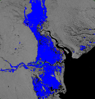
  • Flood extent derived from a satellite image, using GEE
  • Example of a flood risk map generated by the application
  • Map estimating the extent of floods and elevations in different regions

Images of the analysis and product

User guide

How does the platform work?

Join us in the flood risk management revolution

For developers and investors

Join RAS and be part of our mission to revolutionize flood risk management. We are looking for developers to join our team and donors to help fund this innovative project.

Why join us?

For developers

Join us to work on developing our product and make a tangible impact in the agricultural sector. Use your skills and experience by collaborating with us in remote sensing, GIS, and software development.
Share your CV and join the team →

Become a product partner

For investors

Support our mission to help farmers mitigate the impacts of floods and protect their livelihoods. Invest in our cutting-edge technology that revolutionizes flood risk management for farmers. Your investment will drive the development and expansion of our platform, ensuring high returns through innovative agricultural solutions.
Contact Us

Contact Us

📍 Curridabat, San José, Costa Rica
📞 +506 8338-5376